Map Collection

Historical maps (sixteenth – nineteenth century)
Modern maps
The 'modern' maps can be found in
Holger Przibytzin
Tel.: +49 (0)251 83-25516
holger.przibytzin@uni-muenster.de
Substitution:
Jessica Thomas
Tel.: +49 (0)251 83-24063
jessica.thomas@uni-muenster.de
Dr Henning Dreyling
Tel.: +49 (0)251 83-24068
dreyling@uni-muenster.de
It was only after the Second World War, that a map collection was established at the University and State Library of Münster. Apart from continuously obtained official maps, such as the topographical, geological, hydrogeological maps and the German basic map which were all issued by the Landesvermessungsämtern of the German states (Ordnance Survey), the University and State Library of Münster obtains, according to the "Kulturgesetzbuch NRW" (Cultural Code of North Rhine-Westphalia), a specimen copy of each map released by publishers or municipal corporate bodies. These are especially city and site maps, hiking, touring or street maps from the areas of the administrative regions Arnsberg, Detmold and Münster. We are currently developing a special catalogue providing a list of geographical maps.
Apart from the more recent maps, the University and State Library of Münster offers a collection of historical maps from the sixteenth to the nineteenth century. This collection consists of two parts:
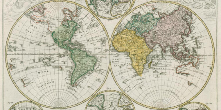
Regional distribution of map sheets: World maps (spherical surface, eastern and western hemisphere), large-scale maps of the European States, few of Northern and Southern Europe, numerous sheets are representative show pieces of the Amsterdam and Nuremberg-Augsburg era, Prussian provinces and German states and regions as well as city maps.
Dating of historical maps: The end of the sixteenth and seventeenth century is represented through famous mappers such as Gerhard Mercator and Abraham Ortelius, as well as through the publishing houses Hondius, Janssonius, Blaeu, Visscher, Schenk, Valck, Ottens, Mortier and Danckerts.
Maps from the southern German centers for cartography, represented by Johann Baptist Homann in Nuremberg as well as by Seutter and Lotter in Augsburg date back to the end of the seventeenth and eighteens century.
The strongest presence, however, has the nineteenth century with Berlin mappers such as Simon Schropp, D. F. Sotzmann, F. W. Streit and others, examples from Weimar, Gotha and Leipzig (Landes-Industriecomptoir and Geographical Institute of Weimar), Adolf Stieler, Justus Perthes, Hellfarthsche Verlagsanstalt (Hellfarth Publishing House).
The collection is listed in the Systematic catalogue.
The spectrum of content of the map collection ranges from general maps of the earth and sky, special regional maps (region of Westphalia), topographical-military maps, battle plans, maps of the soil culture, land cultivation and agricultural constitution to city maps from the first half of the sixteenth to the middle of the nineteenth century. Furthermore, it includes travel and boundary maps.
The maps are searchable in
Literature:
Bertram Haller / Günter Tiggesbäumker: Die Kartensammlung des Freiherrn August von Haxthausen in der Universitätsbibliothek Münster
Locations: reading room WES 2.72 MUS 26 and manuscript reading room WES 2.61 Hax 150