
Die UB Leiden hat im Sommer 2022 vermeldet:
Three enormous maps of China, created during the reign of three different emperors of the Qing dynasty, have now been made available in open access and are downloadable via Leiden University Libraries’ (UBL) Digital Collections. The rich maps are an early example of academic collaboration between the Imperial Chinese court and Western missionaries and are considered a cornerstone of Chinese cartography.
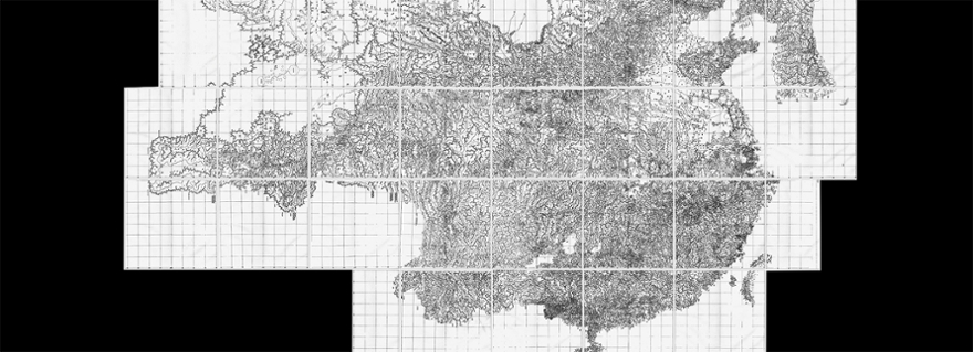
Maps
The three maps, the largest about 8m high and 10m wide, show China as it was during the prime of the Qing dynasty. They were commissioned by three emperors: Kangxi (1721), Yongzheng (1728) and Qianlong (1766), respectively. Land surveys for the production of all maps were performed by Jesuit missionaries, first during the reign of the Kangxi Emperor, who had shortly before decided to allow Christian missionaries into China. This academic collaboration, including on the position of missionaries at the Imperial Court and events during their travels throughout the Empire, is still a source of much sinological research.
It is quite rare for the full set of maps to be present in a single institution, although fragments can be found in library collections around the world. The reason for this was the importance of the maps for European cartographers. Well into the nineteenth century, these Chinese maps were used as a blueprint for maps of China in Europe. Several imperfections can also be found on these European copies. Conscious adjustments made to correlate the map with classical Chinese stories and folklore were also adopted.
Education and research
The initiative for digitising the maps came from the Manchu Foundation and founder and project manager Fresco Sam-Sin, an organisation aiming to bring knowledge about the Manchu language and people to a wider audience. The foundation used the digitised maps in the Leiden Digital Collections by means of IIIF technology for various projects, such as the QingMaps website and for an interactive experience in an exhibition at the Dutch National Museum of Ethnology. As a result of a five-year project, the maps are now almost completely indexed. The project, digitisation and cataloguing, was funded by the UBL, the Leiden University Faculty of Humanities, the Manchu Foundation and University of Macau, where Mario Cams has been conducting research on these specific maps for years.